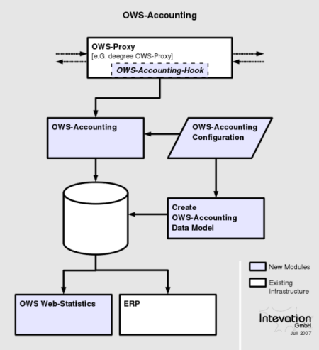
About OSAAS
OSAAS is a tool to track access to your OGC web services for the purpose of statistics. In addition to that, an integrated user authentication enables you to take account for accessing OGC services.
OWS stands for OGC Web Services which are the basis for Spatial Data Infrastructures (SDIs). OGC stands for Open Geospatial Consortium, the organization that specifies the web services. Examples for these services are WMS (Web Map Service) and WFS (Web Feature Service).
OSAAS is Free Software, most of it licensed under GNU GPL (the server). Other parts depend on the respective clients (e.g. GNU LGPL for deegree).
Downloads OSAAS
To download the most recent released software you can follow the links below to the development-platform.
Current Release:
https://wald.intevation.org/frs/download.php/797/osaas-server-1.0.1.tar.gz
https://wald.intevation.org/frs/download.php/836/osaas-doc-1.0.1.pdf
Old Releases:
https://wald.intevation.org/frs/?group_id=33
Developers Corner
OSAAS development is coordinated at Wald, a gforge based plattform at
http://wald.intevation.org/projects/osaas/.
There is also a BugTracker and several mailinglists to join for further development.
To get the latest code, you could check out the latest SVN-trunk or browse the tree online.
Contact / About this site
To contact the development team of OSAAS you can subscribe to the development-mailinglist.
Currently OSAAS is developed mainly by
Intevation GmbH
Neuer Graben 17
49074 Osnabrück
Germany
http://www.intevation.de/geospatial/index.en.html